top of page


Construction Progress Monitoring

Solar & Renewable Energy Solutions


From early-stage planning to long-term operations, That Drone Guy USA provides aerial data collection and mapping services that help solar developers, engineers, EPC contractors, and asset managers make informed decisions throughout the life of a project. Our advanced drone platforms capture high-resolution imagery, LiDAR data, thermal imagery, and orthomosaic maps that provide a comprehensive view of solar sites before, during, and after construction.


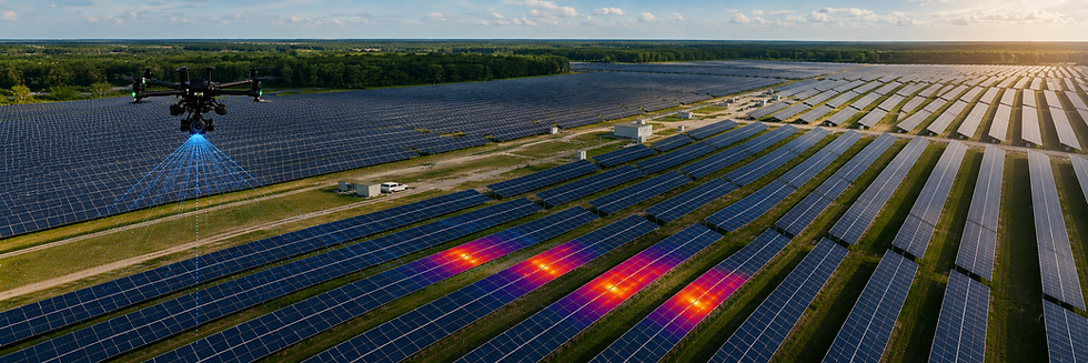
Drone-based solar inspections allow facility owners and operators to evaluate large areas quickly, safely, and efficiently. High-resolution aerial imagery combined with thermal imaging provides a detailed understanding of site conditions, panel performance, vegetation management concerns, and infrastructure status. Whether supporting routine maintenance, warranty documentation, insurance requirements, or performance evaluations, our inspections deliver actionable information that helps keep renewable energy assets operating at peak efficiency.
Successful renewable energy projects begin with accurate site information. Our drone-based LiDAR mapping, orthomosaic mapping, and site grading analysis services provide the data needed to evaluate terrain, identify drainage patterns, calculate earthwork quantities, and support project planning. By capturing detailed existing conditions quickly and safely, project teams can reduce field time while improving confidence in design and development decisions.
Solar Development Support
Large solar installations require accurate documentation throughout every phase of construction. Our construction progress monitoring services provide project stakeholders with current aerial imagery, site overviews, and visual reporting that help track milestones, verify contractor performance, monitor grading activities, and document project progress. Regular aerial updates create a historical record of the project while improving communication between owners, developers, engineers, and construction teams.

Once operational, utility-scale solar facilities depend on consistent performance across thousands of panels. Using advanced thermal imaging technology, we identify potential issues such as hot spots, failed modules, damaged cells, connection problems, and underperforming arrays before they become costly production losses. Our thermal solar panel inspections support solar asset management programs by helping operators prioritize maintenance, maximize energy production, and extend the life of
critical infrastructure.
Thermal Solar Panel Analysis & Asset Management
Solar Facility Inspections
Our team combines advanced drone technology with practical experience in mapping, documentation, and data collection. With over 1,000 flight hours, more than one million images captured, and a mobile command center equipped to support projects nationwide, we deliver reliable aerial intelligence for solar developers, engineers, construction teams, and facility managers. From site selection monitoring through operations and maintenance, we provide the accurate data needed to support smarter decisions and better project outcomes.
Solar Facility Monitoring
Solar Facility Monitoring
ONCE THE SOLAR
FACILITY IS COMPLETE.

bottom of page